Find the Data You Need By Legislative District
Whether you are seeking a grant, planning a program or advocating for legislation, data that are available by legislative district often can be helpful in making your case. Kidsdata provides data by legislative boundaries in a variety of categories.
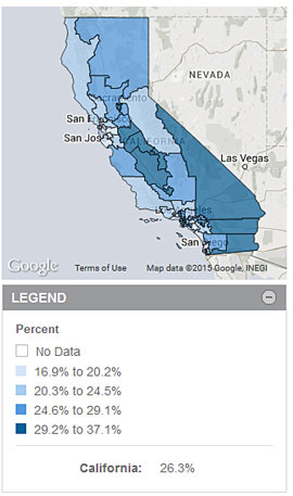
A recently posted example is children living in food insecure households, which is cut by Congressional District. Other data sets that are available by legislative boundaries include child population; immigrant children; disconnected youth; children with special health care needs; homeless children; family economics; and more.
If you want to see all available data for a particular district, find it in the Data by Region section. Alternatively, type the district name into the search bar and you will be presented with a list of all indicators with data for that district.
Unfortunately, many data sets are not cut by legislative boundaries. For this reason, kidsdata allows users to overlay legislative district boundaries on maps for all data sets. Select an indicator, choose the map view, then click Legislative Boundaries. This enables you to visualize what’s happening in Congressional, State Senate, or Assembly districts for data not cut by their boundaries.
You can use legislative information to:
- Create maps showing critical child health and well-being data for your district
- Identify data "hot spots" and areas of need
- View data from previous years to see changes in your district over time
- Print maps to take with you to advocacy or policy meetings
Kidsdata Tip
To learn how to create customized data visualizations, view our kidsdata tutorial, which shows you how to select trend charts, bar graphs and maps, and tailor them to meet your needs.
|
Children Living in Food Insecure Households, by Legislative District
Year: 2012

|

